


Free Gps For Boat fishing
Description de Free Gps For Boat fishing
Soyez prudent après l'installation de l'application et l'apparition de la carte, fermez et rouvrez l'application pour qu'elle fonctionne correctement.
Cartes: Satellite, Simple, Terrain, OpenStreetMap, Seamap, OpenTopo
Le GPS pour la pêche en bateau est le même que le GPS pour la pêche en bateau et la voiture - Pro Gps pour la pêche en bateau et la voiture - Pro
n'a pas d'annonces est plus léger plus rapide et a une utilisation illimitée sans abonnements.
Ce GPS est spécifiquement destiné aux pêcheurs amateurs
mais cela ne veut pas dire que ce n'est peut-être pas un outil utile pour la voiture ..)
nous améliorons constamment l'application pour une utilisation simultanée dans les voitures et les bateaux
nous avons également amélioré la façon dont les itinéraires et les cartes sont stockés, les cartes sont enregistrées
ouvrez-le et modifiez-le, vous n'avez rien d'autre à faire et à enregistrer
les itinéraires que vous souhaitez utiliser et que vous êtes prêts à utiliser en dehors du réseau,
les itinéraires de la voiture sont enregistrés dans des fichiers .json que vous pouvez modifier,
les itinéraires du bateau sont stockés dans des fichiers .txt / csv.
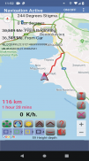
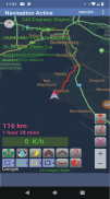
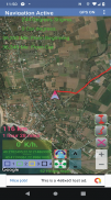
Orientation et navigation faciles vers la marque.
Recherchez la ville ou ce que vous voulez, comme les stations-service, les restaurants, etc., puis trouvez l'itinéraire le plus proche ou le meilleur que vous souhaitez emprunter,
lorsque l'itinéraire est affiché, vous verrez la distance et le temps qu'il vous faudra pour atteindre votre destination,
la recherche de zone vocale au sein du réseau est prise en charge,
après avoir trouvé l'emplacement et affiché l'itinéraire, vous prenez également en charge le guidage vocal.
Mode trafic, vous pouvez voir en direct là où il y a des embouteillages et en choisir un autre
itinéraire ...
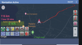
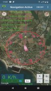
Explorez les sites portuaires, naviguez en toute sécurité et allez dans le bon sens
trouver des ancrages et plus
les cartes fonctionnent également hors ligne, car chaque emplacement ouvert en même temps est stocké
dans la mémoire du téléphone dans le dossier (osmdroid), vous remarquerez que la première fois retarde expiré en fonction de la vitesse
du réseau, cela signifie qu'au fur et à mesure que nous traitons plus de sites, plus de bits sont stockés dans la mémoire du téléphone.
Si vous voyez plusieurs emplacements et que vous avez de l'espace sur le téléphone, vous pouvez supprimer le dossier (osmdroid) pour qu'il démarre
depuis le début (notez que la suppression de l'application (osmdroid) ne supprime pas, vous devez la trouver et la supprimer si vous ne le souhaitez pas.)
quatre répertoires de stockage
où vous pouvez stocker autant de spots que vous le souhaitez
vous pouvez planifier les prochains itinéraires en trouvant des points sur la carte en stockant
dans une liste dans l'ordre dans lequel vous voulez qu'ils soient prêts à les utiliser.
Dans StreetMap, vous pouvez planifier des itinéraires et enregistrer ...
Si vous cochez Trace, vous pouvez l'enregistrer à la fin de l'itinéraire ...
Les chemins programmés et la trace d'itinéraire peuvent être extraits dans des fichiers (GpsFile / Name.TXT - .csv & RoadSave / Name> Name.json)
Quatre souvenirs de piste pour savoir à quel prix vous êtes allé et vous aider à frapper un
pièce sans laisser de vides ni passer par le même endroit
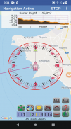
1) Positionnez l'azimut d'où nous étions
2) Azimut directionnel pour atteindre la stigmatisation
3) Kilomètres ou miles du début au point où nous allons
4) Kilomètres ou miles de distance de l'endroit où nous sommes au point où nous allons
5) Vitesse en kilomètres ou miles par heure
6) Coordonné par la stigmatisation dans laquelle nous allons
7) Coordonnées d'où nous sommes
8) Mesure de distance de trois manières différentes
9) Mesure d'altitude
10) Pistes permanentes
disponible deux autres pages dont une avec les listes au choix
et une page de sauvegarde en trouvera également une
page d'aide.
Ils sont simples à manipuler afin qu'ils puissent l'utiliser
en toute simplicité ...
Free Gps For Boat fishing - Version 19.9
(03-10-2021)Free Gps For Boat fishing - Information APK
Version APK: 19.9Package: com.gpsfile.gpsforboatAncienne Version de Free Gps For Boat fishing
Autres versions


 4.15
4.15


Applications de même catégorie


Vous pourriez également aimer...


